General Information
Lakes : The Mirrors of the EArth
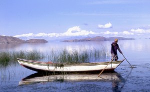 Lakes contain large volumes of freshwater readily accessible for human uses. As such, lakes, whether natural or artificial (reservoirs) are dramatic and highly-visible features of the global landscape. They also provide a wide range of life-supporting and economically-important ecosystem goods and services. Our planet contains an estimated 27 million natural lakes with surface areas greater than 1 ha, with the 17 largest natural lakes covering an area of about 100 million ha (1 million km2). There are an additional half million artificial lakes (reservoirs) with surface areas exceeding 1 ha. These water bodies collectively contain more than 90% of the liquid freshwater on the surface of our planet at any given instant. Being major lentic water systems easily accessible to human exploitation, lakes are used for a wider range of human purposes than any other type of freshwater system, which also makes them more susceptible to water use conflicts. Lakes exhibit several defining characteristics, including, (1) a long water residence time, (2) an integrating nature for all inflowing water and material inputs, and (3) non-linear responses to human interventions (so-called hysteresis property), all of which complicate their accurate assessment and effective management. In fact, being integrating ‘sinks’ for inflowing waters and the materials carried in them, lakes represent valuable barometers of the impacts of human activities within their drainage basins, with their degradation often being a trigger for freshwater management interventions.
What’s TWAP?
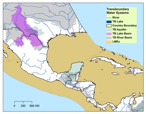
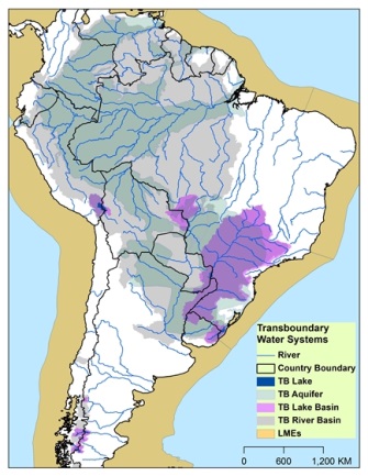
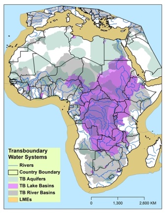
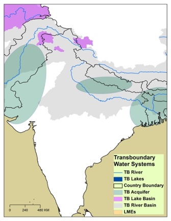
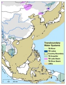
The TWAP (Transboundary Waters Assessment Programme) is an international project funded by GEF: Global Environmental Facility to conduct a global-scale assessment of five major types of transboundary water systems (Lakes, Rivers, Groundwater, Large Marine Ecosystems, Open Oceans) (Figures) for the purpose of ranking them, in their respective types, in regard to their degree of vulnerability to human impacts. The results of this global assessment will provide the GEF with a means of establishing priorities in regard to the most effective funding allocations within its International Waters portfolio.
TWAP-Lake Group Activities
After completing an initial TWAP medium-size project focusing on the development of assessment methodologies, and in collaboration with the United Nations Environment Programme (UNEP), the International Lake Environment Committee Foundation (ILEC) initiated a TWAP-FSP (Full-Size Project) to rank transboundary lakes and reservoirs, utilizing a GIS-based spatial and analytical methodology with relevant indicators. This project is being pursued in collaboration with the Research Center for Sustainability and Environment (Shiga University, Japan) and the Meadows Center for Water and the Environment (Texas State University, USA).
Meetings
ILEC has established a Lakes Working Group to undertake the primary lake and reservoir component of TWAP. To date, the group has organized and convened nine Lakes Expert Group Meetings, as follows:
(1) Project Inception Meeting (May 13-16, 2013, ILEC Headquarters, Japan);
(2) East/Southeast Asia Expert Group Meeting (July 8-11, 2013, Kuala Lumpur, Malaysia, supported by NAHRIM);
(3) East Africa/Europe/Central Asia Expert Group Meeting (September 19-22, 2013, Perugia, Italy);
(4) Consultative Meeting for Central Asia (November 5, 2013, ILEC Headquarters, Japan);
(5) Central America Expert Group Meeting (December 2013, Guanajuato, Mexico);
(6) South America Expert Group Meeting (December 2013, Rio de Janeiro, Brazil);
(7) South Asia Expert Group Meeting (January 2014, Delhi, India, in collaboration with Chilika Development Authority);
(8) Africa Expert Group Meeting (February 2014, Nairobi, Kenya); and
(9) Consultative Meeting with South Asia and Southeast LME Group (March 2014, Manila, Philippines)
Additional Lakes Expert Group Meetings are being scheduled in the coming few months, including Central/West Asia Expert Group Meeting and West African Sub Region Expert Group Meeting.
Activities and Progress
The Lakes Working Group has been conducting the following three major activities:
(1) Activity-1: Identifying priorities for transboundary lake basins
– Delineation of the areal boundaries of approximately 160 GEF-eligible and 50 non-GEF-eligible transboundary lake and reservoir basins, using GIS-based technique, combined with remote sensing data and a digital elevation model;
– Identification of indicators, with relevant data collection, GIS analysis, and evaluation, to rank the lake and reservoir basins in regard to their vulnerability to human activities. Determining the relative importance of these indicators is a continuing activity being conducted on a sub-continental/regional basis.
(2) Activity-2: Identifying and characterizing sub-continental/regional issues and challenges
– Preparation of sub-continental/regional GIS overlay maps on a global scale to illustrate the hydrologic linkages between the focused transboundary lake and reservoir basins and their nearby transboundary river basins, groundwater aquifers and large marine ecosystems;
– Collecting data of biodiversity hotspots, land degradation, and land uses and overlapping them onto these sub-continental/regional maps to highlight water-related issues and characterize each sub-continental/regional area
(3) Activity-3: Developing frameworks and methodologies to assess the status and management needs of lake and reservoir basins and to rank and prioritize transboundary lakes
– An integration of the causal framework “Driver Forces – Pressures – States – Impacts – Responses” (DPSIR) with the interface framework of “Provisioning/Cultural/Regulating/Supporting Ecosystem Services” in ecosystem management into a new assessment framework “Stress – Impairment – Impacts”;
– An application of the analytical approach “Analytic Hierarchy Process” (AHP) and the operational approach “Multi-criteria Analysis” (MCA) in decision-making science to the above integration; and
– An implementation of the technique of “Questionnaire Survey” (data format as interval scale scores), in addition to the computer-based techniques “Geographical Information System” (GIS) and “Remote Sensing” (RS) (data format as criteria indicator values), to enhance the effectiveness of the overall assessment.
Assessment Results
Summary
- The TWAP Lakes Component comprised 206 transboundary lakes, using analysis of NASA global-scale database. However, there was sparse data on the areal extent of the majority of transboundary lake basins, necessitating combined GIS-based spatial analyses and digital elevation model calculations to delineate the majority of the transboundary lake basins.
- The list of 206 transboundary study lakes was reduced to a final list of 53 lakes on the basis of specific areal, population density and temperature criteria deemed suitable to identify the lakes meriting the most attention, including 23 African, 8 Asian, 9 European, 6 South American, and 7 North American transboundary lakes.
- A Scenario Analysis Program was developed to compute the relative lake threat ranks on the basis of computed scores derived from indicators which were consisted of Human Water Security (HWS) Threats and Biodiversity Security (BS) Threats, 23 drivers, and 20+ Filtering Parameters. The 23 drivers were conducted by Vörösmarty et al. (2010) and were grouped under the thematic areas of catchment disturbance, pollution, water resource development, and biotic factors.
- A knowledge-based system with an extensive literature resource base, LAKES (Learning Acceleration and Knowledge Enhancement System), was also used to substantiate more accurate conclusions regarding the status, potential and priority for addressing the lake threats.
- Used in conjunction with a Scenario Analysis Program for selecting specific filtering criteria for computing the threat ranking, however, it highlighted that the calculated ranks can be misleading for transboundary lake comparisons unless the factor(s) for the user of the ranking was considered.
- The transboundary lakes also were evaluated with a parametric sensitivity analysis, assigning differing relative importance (weight) to the Adjusted-HWS, which reflects the degree to which investments in infrastructure, and BS threats in the ranking process, as well as inclusion of the Human Development Index (HDI).
- These multiple ranking experiences also provided guidance regarding which lakes was most likely to benefit from GEF-catalysed management interventions.
Several important conclusions merit emphasis:
The lake threat ranks can be change significantly when different ranking criteria or preconditions are given differing importance in the analysis. An accurate and meaningful risk assessment requires consideration of a range of interacting scientific, socioeconomic and governance issues, whose relationships can be very subtle and incremental in impact. Selection of appropriate context for gaining meaningful understanding of the relative lake threats remains the task of the user of the ranking results;
The significant scarcity of uniform lake data on a global scale, including in-lake data needed for comparative lake analyses, compels the international water community to undertake knowledge base development focusing on lakes and other lentic water systems, including their links with upstream and downstream water bodies. Our increasing knowledge of the role of lakes in influencing such global-scale issues as climate change impacts and fisheries vulnerability also merits greater discussion in the international water arena;
The assessment process encompassed within the Scenario Analysis Program developed for the Lakes Component of TWAP, allowing the user to select specific ranking parameters and develop appropriate context for interpreting the results, is also a significant contribution to the transboundary lakes assessment, one as important as the ranking results themselves;
Future transboundary water assessments will be more useful and realistic if the hydrologic and jurisdictional links between transboundary water systems, and their defining characteristics, are considered. Thus, future transboundary assessment working groups should include representatives from each transboundary water media working collectively;
Although the activities associated with future transboundary assessments can be incorporated within future programmes of UN and other international agencies to some degree, a core requirement for undertaking future assessments will be the availability of sufficient, sustainable financial resources and collaborative institutional support.
The International Lake Environment Committee Foundation (ILEC) developed an integrated approach (Integrated Lake Basin Management (ILBM) ) to address deficiencies of Integrated Water Resource Management (IWRM) which are not readily amenable to addressing lentic water system issues, focusing on the sustainable management of transboundary and non-transboundary lakes through gradual, continuous and holistic improvement of basin governance, including sustained efforts for integrating institutional responsibilities, policy directions, stakeholder participation, scientific and traditional knowledge, technical possibilities, and funding prospects and constraints. It expands consideration of water resources from a strictly hydrodynamic-hydrostatic physical context, to more as an expression of the ecological and anthropogenic state of freshwater, with evolutional and historic memories of human-nature interactions, including their lentic-lotic water links. Focusing on sustainable ecosystem services, the conceptual ILBM framework represents a platform or virtual stage for collective stakeholder actions to improve lake basin governance, thereby complementing the existing IWRM approach.
Explore Assessment Results
The Assessment results can be explored in detail in the ILEC TWAP Lakes Portal. More Information on the methodology, the assessment results and the data maps can be found here.
General information on the TWAP project is available on the TWAP project website, while more detailed information regarding the transboundary lakes and reservoirs component of TWAP is available on both the ILEC website and the website of the Meadows Center for Water and the Environment at Texas State Universitya>.
